Location Elevation Description How to Find
Sima de la Forcadoņa (I41)
Explored mainly by SEG in 1985, I41 makes for a fine trip down to 267 m with hardly a foot on solid floor until the Sala Dunkin is reached at 240 m. It is situated between top camp at Vega Huerta and the southern wall of Peņa Santa. Its packed with interest, with pitch-ramps, ruckles and water.
Location X: Y: Z m Depth -267 m
Surveys
Description
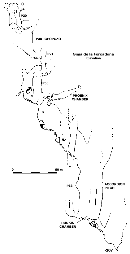
Descend the entrance pot to land on a snow plug 10 m below. The continuation is via a rift which opens in the wall above, leading to the head of Geopozo, a 30 m pitch finishing in a small chamber. A 21 m pitch is then followed by a 33 m pitch (paralleled by another shaft with waterfall) to an area of break down. From here, a slope leads up to Phoenix Chamber, where a fault plane can clearly be seen.
A hand line descent to the right hand side leads to the next pitch head, where there are many unstable blocks. This rather damp pitch leads on to a pitch-ramp descending for around 40 m with dangerously unstable blocks and stones for company on to a boulder slope. A dangerous descent may be attempted with a water fall and potentially the boulders can be made from here. Alternatively, Accordion Pitch, an enormous 63 m shaft can be descended into Dunkin Chamber, an oval chamber, measuring 30 × 60 m, from which the base of the lateral shaft may also be accessed. From the chamber, descent of 20 m through a boulder ruckle leads to a choked aven at 267 m depth.
How to Find
I41 is located approximately 10 minutes from top camp. A gaping hole, it is situated on the eastern slope of a small ridge that rises from Vega Huerta and ascends towards the north before reaching the Peņa Santa face.


